DNR supports key FMR-sought protections for metro river corridor

Thanks to the many voices that supported strong river protections this summer, new state rules governing land use and development along the Mississippi River in the Twin Cities strengthen existing and create new, important river protections.
Due to its outstanding natural, scenic, cultural and recreational resources, the metro stretch of the river from Dayton to Hastings was established as a state critical area (the Mississippi River Corridor Critical Area, MRCCA) in 1976, and then as a national park (the Mississippi National River and Recreation Area, MNRRA) in 1988. Regulations for development within the 72-mile corridor have been in place since the late 1970s, but after prompting from FMR the Minnesota Department of Natural Resources (DNR) has been working closely with local cities and river stakeholders to craft updated rules that better reflect the national significance of our metro riverfront.
Now in their final review phase, the new rules will do a much better job identifying and protecting the river’s unique resources. They also better reflect both existing and planned development, so cities along the corridor can continue to grow and embrace their riverfronts while also preserving it for future generations.
During the final phase of review by an administrative law judge this summer, FMR provided both oral testimony and extensive written comments — and we had plenty of company! All told, more than 300 pages of comments on the new river rules were submitted, including dozens from FMR allies and supporters.
At the end of the formal comment period in July, the DNR produced two reports summarizing their responses to all the oral and written testimony. The reports include recommendations for additional changes, many of which were inspired by comments from FMR staff, River Protectors and allied groups. They also explain why other suggested changes, some of which sought to weaken the rules, were rejected.

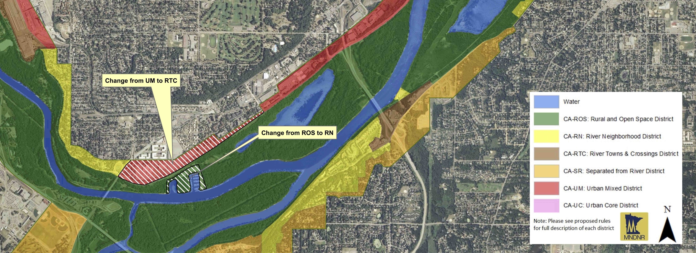
The area along Shepard Road around the confluence of the Minnesota and Mississippi rivers in St. Paul has significant scenic and historic resources. Working closely with community groups and other allies, FMR successfully advocated to change its designation from "Urban Mixed" to "River Towns & Crossings." This effectively lowers the maximum building height from 65 to 48 feet, better protecting the viewshed and neighborhood character.
DNR recommendations
Redistricting
- Proposed river rules establish several zones or districts within the critical area, each with different regulations around building height limits, open space and other important considerations. The updated districts had better reflected today's river, however, FMR and our supporters. advocated for several changes now recommended by the DNR, including:
— Designation of the stretch along Shepard Road from Highway 5 to Rankin — a scenic area at the confluence of the Mississippi and Minnesota rivers that holds significant historical and cultural value — as a “River Towns & Crossings” district, thus lowering allowed building heights from 65 to 48 feet. (See map above.)
— Changing the designation for Nicollet Island to “River Neighborhood” which lowers the allowed building height from 48 feet to 35 feet, which will help to maintain this quaint neighborhood surrounded by parkland.
— Changing Father Hennepin Bluffs Park along Main Street/St. Anthony Main in Minneapolis from “Urban Core” (no building height limit) to “Urban Mixed” (65-foot limit) to ensure the protection of this scenic park and gateway to the Stone Arch Bridge. - The DNR also recommended changing the definition of the “Separated from River” district to ensure future development does not exceed the height of the mature tree line.
- The DNR maintained the “Rural and Open Space” district designation for large privately-owned properties on Lower Grey Cloud Island and the southern end of St. Paul Park, where landowners and local cities had requested a less restrictive district. FMR and others, including State Senator and FMR board member Katie Sieben, argued that these areas are rich with natural resources that need the high level of protection afforded by the rural and open space designation.
Better bluff and view protection
- DNR recommendations better protect our bluff and shorelines by:
— defining a bluff as an 18% or greater slope
— prohibiting structures within established bluff and shoreline setbacks, and
— limiting vegetation removal and land alteration on and around bluffs and shorelines. - Scenic protections were enhanced by:
— holding the line on height limits,
— requiring visual impact studies for conditional use permits seeking greater height allowance, and
— requiring mitigation for granted height variances.
Defending open space
- The DNR also provided solid reasoning why new expanded rules requiring open space do not constitute a "taking" of property, which would require compensation. They also maintained the 50% open space dedication requirement for river-adjacent properties that are 10 acres or more in the Rural and Open Space district.
Overall, FMR is pleased with the final rule package, including the DNR’s recommended changes. The administrative law judge's report supports the rules moving forward to adoption, although the DNR will need to address a few technical issues. The DNR has until mid-February to formally adopt the new rules. After that, the DNR will work with the 30 local units of government in the corridor to update their local plans and ordinances to better protect our local national treasure.
Stay connected
Sign up to become a River Protector and be sure to click "I will advocate for the vitality of the Twin Cities river corridor, our national park," and we'll make sure you receive future MRCCA communications from FMR.
Learn more
• Basic MRCCA overview
• MRCCA in detail, including links to the judge's report and the DNR's response to comments.