600 Main Street SE Development

The site in question is visually at the northern end of the Stone Arch Bridge. The proposed development would put a 70-foot wall of apartments at the end of the bridge, where the cars are parked in this photo.
Whats Proposed
Developer Steve Minn, with Lupe Development, is proposing a six story, 79 unit residential development at 600 Main Street SE along the St. Anthony Falls riverfront.
The site is in a truly iconic civic location. It is between the designated riverfront parkway through the area (Main Street SE) and the riverfront. And it is at the terminus of the historic Stone Arch Bridge.
Community Planning for the Site
The City approved its Comprehensive Minneapolis Plan for Sustainable Development earlier this year. The Plan calls for the parcel to be acquired for a public park. An earlier neighborhood planning process for the surrounding Marcy-Holmes neighborhood first identified the site as an ideal location for a park.
Unfortunately, the Minneapolis Plan for Sustainable Development does not hold full legal authority until it is approved by the Metropolitan Council, which for other reasons may not occur until September. But critically and regardless of park considerations - there are many reasons not to approve a building on the site. Thats true even under the current zoning and planning in place already, as is explained below.
What the developer is asking of the City
To build the project, the developer needs three zoning approvals:
- A conditional use permit to increase the number of housing units allowed on the site from four to 79.
- A conditional use permit to increase the height from four stories and 56 feet to six stories and 70 feet.
- A variance to reduce the minimum lot area per dwelling unit (in other words, increase density), by 30 percent.
FMR, like City staff, is recommending denial of the variance and conditional use permits.
Why the project is wrong for the site
Park designation aside, we believe there is a set of three other realities that on their own compellingly point toward denial of the zoning changes:
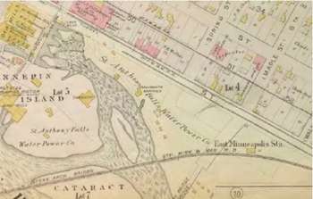
As this parcel map shows, as far back as 1885, intensive development was congregated on the opposite side of Main Street.
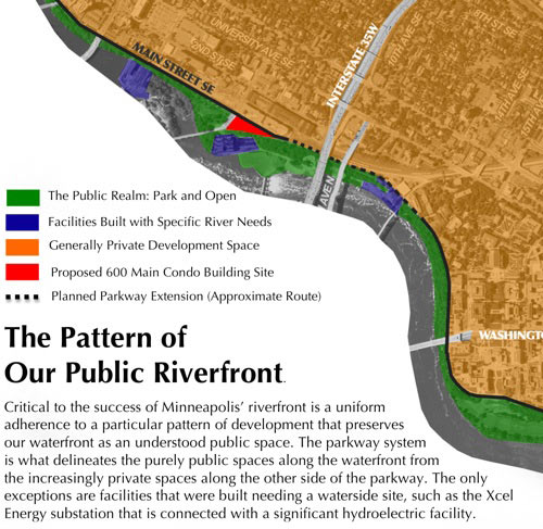
- This is a unique location of major public significance located between the parkway, river and historic Stone Arch Bridge. The Minneapolis parkway system is beloved because the land on the waterfront side of parkways has been uniformly preserved as a deeply public space. Only a handful of exceptions have been allowed to this principle, usually for water-dependent facilities like power plants.
Minneapolis Mississippi River Critical Area Plan says that in the Central Riverfront, the greenway system [should be] improved and extended through land acquisition and easements. Priority is given to extend existing Main Street to connect with East River Parkway at the University of Minnesota. As the map below demonstrates, the proposal under consideration would represent a striking exception to this surrounding pattern of public space. While the owner has a right to develop the parcel, care should be taken to ensure any building integrates well with its surroundings, which includes riverfront parkland, and the connection to the historic Stone Arch Bridge. Permitting more intensive and more dominant private uses would diminish the public sense of place, stake, and potential in this key civic node. - This is a riverfront location where development is to be limited in height. As noted in the staff report, the Mississippi River Critical Area Plan provides key guidance on building massing for this site:
In general, structures within the Critical Area should be shorter when located closer to the river. Taller structures are possible within the Critical Area as distance from the river increases or measures are taken to provide some level of screening, buffering and/or enhancement of views of and from the river.
The nearest and closest analogue is Phase One of the Stone Arch Apartments, directly across Main Street. That building is somewhat shorter than what is proposed here: Stone Arch 1 is 5 stories or 54 feet, while the proposed changes though closer to the river would allow 6 stories or 70 feet. - This is a location at the edge of a Community Activity Center. The limitations on site intensity are further underscored by the sites location just outside a Community Activity Center. The Planning Commission previously rejected zoning changes at this site, The current Minneapolis Plan notes the City will support the development of residential dwellings of appropriate form and density, and to achieve this, the City will, promote the development of well designed moderate density residential dwellings adjacent to...Community Corridors and Activity Centers.
Under the current Comprehensive Plan, moderate density is defined as 10 to 30 units per acre. The zoning changes would allow for 95 units per acre, over triple the density recommended under the Current Comprehensive Plan, and nearly double the density recommended by the pending Comprehensive Plan.
For this reason, City staff recommended denying the projects variance.
Could 600 Main become Stone Arch Park?
The Minneapolis Park and Recreation Board is assessing its options to purchase the 600 Main Site and turn it into a park, as the Citys updated Comprehensive Plan calls for. The Park Board is looking seriously at the potential acquisition of the site. FMR summarized the rationale and financing options for the Park Board.
On July 15th, Park Board Counsel Brian Rice told the Commissioners that up to $1.7 million is available from the Metropolitan Councils Park Acquisition Opportunity Fund, which could be matched by up to $700,000 in proceeds from the Park Board's own I-35W Mitigation Parkland Acquisition Fund. Alternately, the Park Board could pursue purchase of the parcel through a legislative bonding request.
"That's it...let's do it," Commissioner Annie Young said in response.

photo: Michael Hicks
Environmental Review
On July 30th, a friend of FMR filed a petition [PDF, 4.2MB] to request a formal environmental review known as an Environmental Assessment Worksheet (EAW) for the 600 Main Street project. The EAW will look more in-depth at impacts on the sites natural, scenic, historic, and cultural qualities. By law, it will put the pending application for a variance and two conditional use permits on hold until the EAW process is complete.

Drawings from the 1891 Birds eye view of the city of Minneapolis, Minn., Pezolt, Frank, Minneapolis, A.M. Smith. Here we see both the original drawing and a colorized version, showing an attractive, wide-roofed depot adjacent to another structure with a Mansard roof, in the French Second Empire Style that was popular at the time.
There are many things that point toward the need for a more careful review of the project's impacts. For example, it is within the boundaries of a National Park, within the boundaries of a regional park, within the Mississippi River Critical Area, and within a National Historic District. In fact, the law appears to require an EAW be completed.
In the coming weeks and months, the City of Minneapolis is expected to oversee the creation of an EAW. The City will seek formal feedback on the impacts a building on-site would have on everything from the historic character of the district to its conformance with area planning efforts. Watch this space for more details FMR will need the help of others to ensure a fruitful environmental review.
What you can do
- Learn more by reading this web site and following links to other information.
- Write or talk to city council members, especially your own.
- Support Friends of the Mississippi River.
- Send us your thoughts about the project.
Links
In the News8/06/09 Apartments or park? Battle continues in Minneapolis Star Tribune
City Documents
City Staff Report on 600 Main Street SE
Marcy-Holmes Master Plan Public Realm Chapter see objective #6 on page 5-9
Other Documents
Environmental Assessment Worksheet and petition
Mississippi Messages
3/2009: Minneapolis Commission rejects building in key riverfront location
4/2009: Two strikes for proposed rezoning on Main Street
4/2009: Strike three for proposed rezoning on Main Street
6/2009: New proposal for 600 Main Street fails to win staff, Planning Commission support
7/2009: Developer claims hardship in new 600 Main proposal
7/2009: Could 600 Main soon become Stone Arch Park?
8/2009: Citizens call for environmental review of 600 Main development
9/2009: City Council rules that no EAW needed for 600 Main
10/2009: Stone Arch II at 600 SE Main denied
Comments
FMR March 23rd, 2009 Comments
FMR June 8th, 2009 Comments
National Park Service March 23rd, 2009 Comments