Central Mississippi Riverfront Regional Park Master Planning process underway

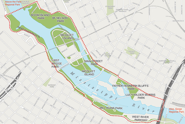
Central Mississippi Riverfront Regional Park Master Plan area
Image: Minneapolis Park and Recreation Board
The Minneapolis Park and Recreation Board (MPRB) began the process of updating the Central Mississippi Riverfront Regional Park Master Plan in 2013. This plan guides development of the parkland along both sides of the Mississippi River in Minneapolis between the bridges at Plymouth Avenue and I-35W. The updated plan will include recommendations for parks development, improved access to parks and to the river, cultural resource interpretation, environmental stewardship, programming and events, as well as operations and maintenance strategies, and priorities, phasing and implementation strategies for the plan.
The planning effort to-date has included significant community engagement and stakeholder outreach. The planning process has followed the pattern of a two-day charrette public meeting followed by a Community Advisory Committee (CAC) meeting that is open to the public. Each month, the charrettes focus on a different geographic portion of the Central Mississippi Riverfront. On the first day of the charrette, the public and local interest groups provide input on the location and share their desired futures for the area. The charrette concludes in the evening of the second day by presenting potential plan designs back to the public for feedback. This feedback is then incorporated and presented later in the month to the CAC for further input. So far, the charrettes have been conducted for Main Street, Waterworks, Hennepin Island, and Nicollet Island.
In January, the planning process will focus on Boom Island and B. F. Nelson Park. The charrette public meetings will take place on Wednesday, January 22 from 8-10am and Thursday, January 23 from 4-5:30pm. The CAC will then meet on January 29 from 6-7:45pm. These meetings are open to the public and are all scheduled to take place in the MPRB Board Room located at 2117 West River Road.
For additional information, please visit minneapolisparks.org.