New bridge signage raises the profile of our national park
Tens of thousands of Twin Cities residents travel through a national park every day and don't even know it. That reality hasn't been lost on the National Park Service and the Mississippi River Fund.
Though Congress designated the 72-mile long Mississippi National River and Recreation Area (MNRRA) as a National Park in 1988, it has maintained a relatively low profile. The National Park Service, in collaboration with the Mississippi River Fund, a local non-profit that funds river protection and restoration efforts, recently set out to raise the Park's profile.
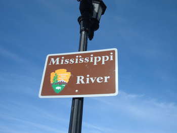
From Anoka to Hastings 35 bridges span the river in the corridor. Each of them provides a unique panorama and reminder of the incredible resource that flows through our community. In recent months, signs have been erected up and down the river to help travelers on the bridges recognize the unique natural setting that surrounds them.
The standard traffic signs come in two basic varieties. One is a smaller Park-focused brown sign with the National Park Service logo and the words "Mississippi River." The other is a larger green highway sign with the National Park Service logo and the words "Mississippi National River and Recreation Area."
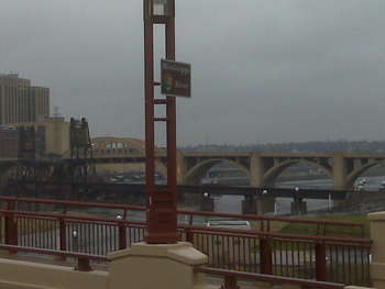
The next time you drive over one of these bridges, you won't just recognize the incredible panorama the river provides. You'll also be reminded that the river corridor is recognized for its nationally-significant natural, scenic and historic values -- all at the heart of a thriving metropolitan area.
Katie Nyberg of the Mississippi River Fund provided commentary on the new signage to Minnesota Public Radio earlier this fall.