From St. Paul to Hastings, big riverfront rail changes in the works
The Mississippi River has long connected downtown St. Paul and Hastings, but for over a century these two cities have been connected through the river valley by a key railroad corridor as well. In the coming years, rail traffic is expected to increase significantly throughout this corridor, and railroad and public planners are considering various ways to meet this increased demand.
Freight rail alone is expected to increase 36% over the next decade. On top of that, the St. Paul-to-Hastings rail corridor is expected to handle high-speed Amtrak service to Chicago, a new Amtrak station at St. Paul's Union Depot, and the planned Red Rock commuter rail line.
To handle all that traffic, a Ramsey County-led team is working with the railroads to plan needed capacity improvements, some of which would impact the surrounding river environment.
Along the river across from downtown Hastings, at the base of the river bluffs, the rail line from downtown St. Paul splits into two, with one side of the fork heading to downtown Hastings, the other to downtown Prescott, Wisconsin. Currently a set of switches can accommodate rail traffic at this junction, but at some point in the coming decade's planners say a grade-separated crossing will be needed. Most likely this will take the form of a 30-foot-tall bridge along the edge of the bluffs.
Capacity improvements at the rail junction near Hoffman Road, just east of St. Paul's Union Depot west of the Bruce Vento Nature Sanctuary, pose similar but more pressing challenges. Already, 5 percent of the nation's rail traffic moves through Hoffman junction. Shifts in Amtrak service to Union Depot a couple years from now alone are expected to complicate traffic in this area, necessitating some grade-separation of rail traffic. The result may be a new 30-foot-tall "flyover" bridge that would not only obscure views to the Mounds Park Bluffs but would be a significant visual presence in and on the Bruce Vento Nature Sanctuary.
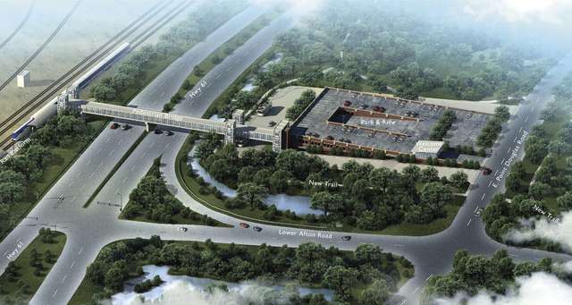
A new station for the Red Rock line at Lower Afton Road would include a ramp and bridge connection to the river.
River Corridor Program Director Irene Jones said FMR appreciates the need to accommodate increased rail traffic, but wants to pursue "all reasonable alternatives to limit impacts to the river environment." After encouragement from FMR, Ramsey County staff to examined the possibility of going under rather than over existing rail-right-of-way. However, due to the area's proximity to the river and several underground springs, tunneling looks to be many times more expensive than a flyover bridge.
Ramsey County and its consultants are now working to provide baseline information to inform environmental review; planners expect to make their final recommendations late this year.
Planning for Red Rock Commuter Rail
While the Red Rock Corridor Commuter Rail from Minneapolis to St. Paul to Hastings probably would not be operational for at least a decade, cities along the corridor are currently in the process of formally adopting plans for proposed riverfront rail stations. Two proposed Red Rock stations fall within the river corridor a station at Lower Afton Road and US 61 in St. Paul and a station in downtown Hastings.
At Lower Afton Road, there aren't plans for new development the site is hemmed in by Pig's Eye Regional Park on one side and bluffs on the other. What is planned is a new two-story commuter -parking ramp on the northeast corner of Lower Afton Road and US61. The current park-and-ride, located around significant Native American sites, would be removed. In addition, a new pedestrian bridge over US61 would be built to serve a rail platform on the other side.
While some have raised concerns about the visual impacts of an above-grade pedestrian bridge at this location, the bridge also has one potential major benefit. St. Paul's planning for the Great River Park indicates the bridge could act as a major gateway to Pig's Eye Regional Park. Bounded by rail lines and industrial uses, the park is currently inaccessible to the public. Both the ramp and the pedestrian bridge are a long way off. With lower anticipated demand, a Lower Afton Road station may not be built until after the line opens.
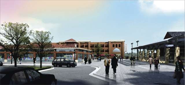
A new station for the Red Rock line at Hastings would include mixed-use redevelopment near the downtown riverfront.
One eagerly anticipated Red Rock-related proposal is the return of rail to the historic rail station in downtown Hastings. There, plans call for a new parking ramp surrounded by new multi-unit housing along the river, and mixed-use development along downtown's main street to extend the character of downtown Hastings eastward including a possible new park space and farmers market. The Red Rock plans generally dovetail with the city's riverfront and downtown development plans.
For more information, see the Red Rock Corridor website.