Rock Island Swing Bridge: An Overview
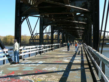
The Rock Island Swing Bridge, as seen from the Inver Grove Heights side in 2008.
For over a century, the Rock Island Swing Bridge has been a unique part of the history of the Mississippi River, and southeast metro area. Against sometimes challenging odds, local individuals and officials have been working successfully to preserve a portion of this areas unique heritage so it can endure for another century.
Bridge History
The Rock Island Swing Bridge alternately known as the JAR or Newport Bridge was built in 1895 by the Pittsburgh Bridge Company. The 1,661 foot long bridge has a rare split-level design. The first level accommodated cars going both ways across the river, while the second level served train traffic. Moreover, a 400 foot section near the middle of the bridge was designed to swing open to accommodate boat and barge traffic.
The bridge is said to have been an escape route of 1930's-era gangster John Dillinger. The bridge was one of the states only toll bridges throughout its history, as it was among the states only enduring privately-owned bridges for autos.
Stabilizing the Bridge
The Rock Island Swing Bridge faces an uncertain future. The bridge has been closed to rail traffic since 1980, and auto traffic since 1999. Deemed unsafe by both Washington and Dakota Counties, the bridge has been closed since 1999. The eastern approach to the bridge was sold to the adjacent Marathon Ashland Oil Company and is currently fenced off as a security buffer.
On October 25th, 2008, the National Park Service rangers offered tours of the eastern portion bridge to the public, and over 1,000 people soaked in the sights, sounds and stories of the bridge. A month after the tour, a 200-foot section of the bridge on the opposite side of the river collapsed.
In the winter and spring of 2009, the eastern portion of the bridge in Saint Paul Park was demolished, including the swinging portion of the bridge. Several spans on the Inver Grove Heights side were also removed to limit access to the remaining portions of the bridge.
Funding and Planning for the Future
In the 2009 legislative session, Rep. Joe Atkins (DFL-Inver Grove Heights) put a spotlight on the bridge. On May 16th, 2009, Governor Pawlenty signed $100,000 in money to be administered by the Minnesota Historical Society and granted to the City of Inver Grove Heights to study and plan for the future preservation of the remaining bridge.
The National Park Service has taken a leading role in preserving the remaining sections of the bridge. Dakota County, owner of the west end of the bridge and surrounding nine acres on the river, is currently exploring recreation and interpretive uses for the bridge. While neither Dakota County nor Inver Grove Heights would like to own the bridge in the long-term, the National Park Service is exploring its options for ownership.
Reuse of 600 feet of the western approach spans could include pedestrian walkways, overlooks, interpretive displays and fishing access. The bridge could help weave together other major investments in the area. In the next five years, over $30 million in public investment is expected near the Inver Grove Heights end of the bridge, including a redesigned Concord Street, new Mississippi River Regional Trail connection, and new Heritage Riverfront Park just north of the bridge site.
FMR Swing Bridge Updates
- December 2008: Future of Rock Island Swing Bridge in flux
- January 2009: Time running out for historic Swing Bridge
- March 2009: Legislators take a stand to save Rock Island Swing Bridge
- May 2009: Rock Island Swing Bridge gets $100,000 reprieve
Outside News Articles
- October 25th, 2008, Star Tribune: Rock Island Swing Bridge pedestrian possibilities
- November 25th, 2008, Star Tribune: Access cut off to Rock Island Swing Bridge
- January 21st, 2009, Star Tribune: Bills might spare historic bridge over river
- February 9th, 2009, Star Tribune: Washington County bridge demolition award draws fire
- February 10th, 2009, Star Tribune: Rogers company to demolish swing bridge
- May 12th, 2009, KSTP: Supporters hope to save Rock Island Swing Bridge
- August 28th, 2009, Star Tribune: Future of Inver Grove Heights swing bridge is tangled among 10 agencies