How does FMR evaluate development plans?

FMR's criteria for evaluating sensitive riverfront development includes alignment with community goals, equitable public access, impact on land and the river and more.
FMR's Land Use & Planning program champions our values of public access, equity, environmental sustainability and community enjoyment of the river. We work with communities to provide technical assistance, grassroots advocacy and policy expertise to ensure that those values are respected throughout time as we change with the river, particularly when new developments are being considered.
Here's an overview of our process and the criteria we use to evaluate potential big changes to our river and its banks.
Our criteria for development plans
While we advocate for open space for wildlife and recreation, we also recognize and celebrate that we're in an urban area. Opportunities for housing, employment and entertainment along the river are necessary to create the vibrant riverfront communities we treasure, as well as to help community members connect to the river.
With these goals in mind, we look to several guiding principles. Questions we ask about developments include:
- Does it comply with Mississippi River Corridor Critical Area rules, including building height and setback, stormwater management and vegetation management? What is the development's impact on the land and on the river?
- Is the plan aligned with comprehensive and small area plans, zoning ordinances and the community's development goals?
- How will it impact the public's enjoyment of the river? Will it impair important or highly-valued views of the river or bluffs, especially those within our local national park?
- Will it support FMR's belief that the Mississippi River is for all of us? Does the plan include public parks and trails, affordable housing, community ownership or other ways to promote equitable riverfront access? Who profits from the river's presence, and can that circle of benefits be expanded?
But those questions are just the starting point. Since each project is unique, we evaluate it as a whole, considering benefits and potential tradeoffs.
Our advocacy process
Since 1993, FMR has worked on policies and plans to guide riverfront development. These policies and plans, such as the Critical Area rules and city comprehensive plans, are created through extensive public involvement processes that often take years to carry out. That's why we advocate for adherence to these policies: They were created for important reasons and represent community voices.
Part of our process that doesn't often end up in the news includes our collaborations with the developer and/or city staff in early plan review phases. Often, this less visible advocacy leads to productive dialogue and better developments. Our advocacy also regularly involves collaborating with local residents, submitting comment letters (many listed on our advocacy page), testifying at public hearings and attending planning commission and city council meetings.
Occasionally, if a development proposal is particularly concerning to us, we sound a louder alarm. That's when you might see an article on our website, be asked to take action as a River Guardian or see FMR in the news.
Here are some examples of past riverfront development projects we've weighed in on.
Protecting the river bluff

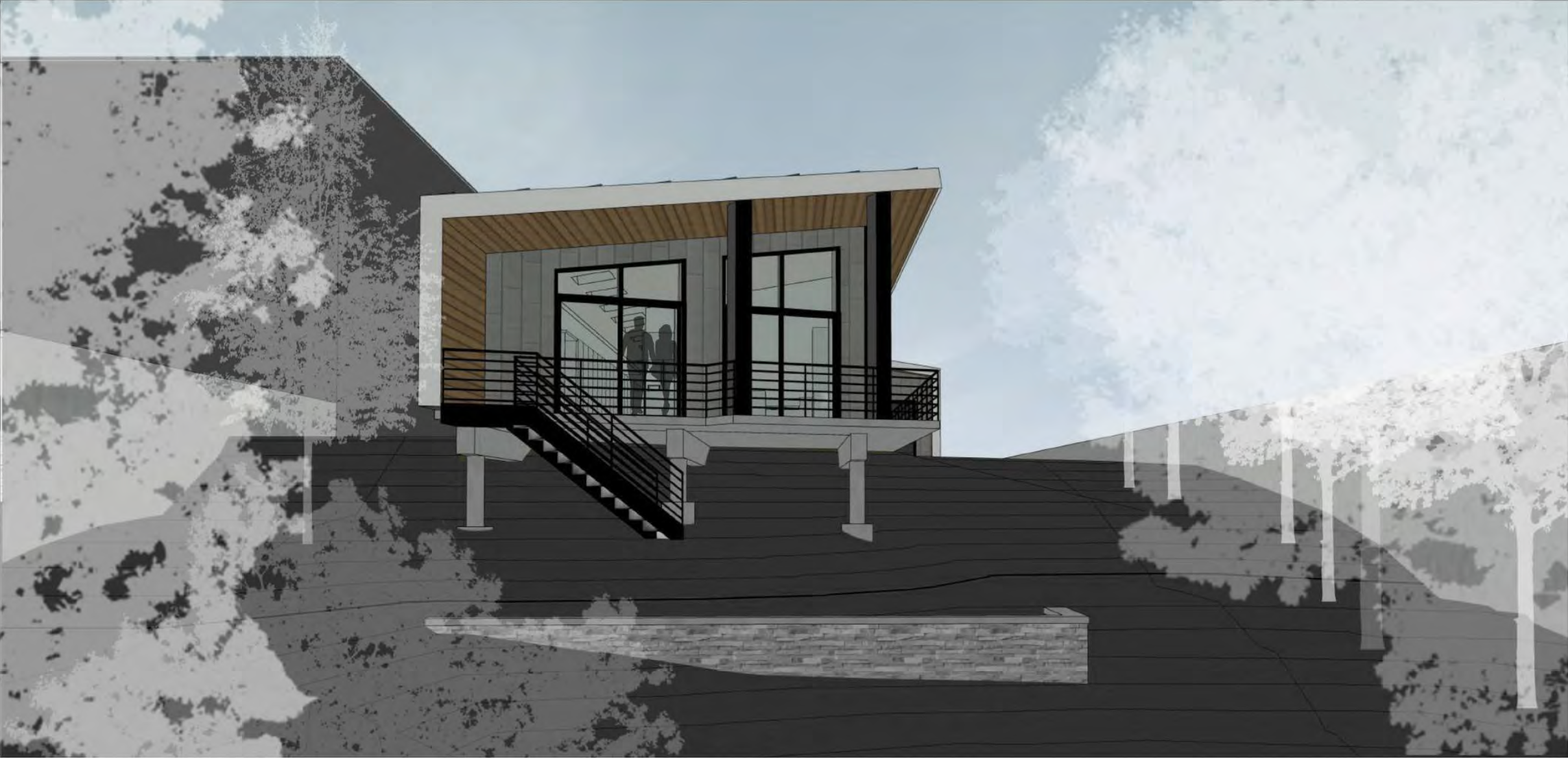
As shown in this rendering, a proposed house in Northeast Minneapolis would be built right on the edge of the river bluff with a deck extending over the edge. However, city ordinance requires such structures to be set back 40 feet from the edge of the bluff to protect both the river and the structures from erosion. (Image by Shelter Architecture)
Case study: Setbacks and standards in Northeast Minneapolis
Just months after Minneapolis adopted its new Mississippi River Corridor Critical Area ordinance in 2021, a riverfront homeowner on Marshall Street Northeast in Minneapolis requested the city's first variance from these updated requirements. The project has tested the city's willingness to uphold consistent riverfront development standards.
In this instance, a property owner wished to build a large garage and an additional single-family home on their riverfront lot (which already contains a duplex). With the right design, this large lot could certainly accommodate the additional density.
However, the owner wants to build their new home right on the edge of the river bluff, with zero setback from the bluff's edge, when by city ordinance and state rules, it should be set back 40 feet. Not only do bluff setbacks protect sensitive habitat areas and scenic views, they also protect structures. Elsewhere along the riverfront, buildings set on the edges of erosion-prone bluffs have deteriorated and developed structural issues.
We don't believe that this project requires this extreme exemption (known as a variance), and we don't believe that the property owner or city have substantiated the requirements (called findings) that the ordinance says any variance must meet.
FMR and other riverfront partners, including the National Park Service, the Department of Natural Resources (DNR) and neighbors, have consistently stated our opposition to this setback variance. When the Minneapolis Planning Commission first approved this project in 2021, we appealed to the Minneapolis City Council and prevailed, stopping the project.
However, the property owner sought approval for the same project again in 2023 without making any modifications to the plan. This time, the Planning Commission denied the variance based on convincing testimony from FMR and others. However, the applicant appealed to the City Council, and the council granted the appeal, allowing the project to proceed.
We thought the council made the wrong decision, as did the DNR. The DNR successfully appealed the city's decision in court, with the judge agreeing that the city illegally approved the project without full consideration of the required approval criteria.
Because this project is one of the first tests of the new Mississippi River Corridor Critical Area ordinances, it's important that the city be held accountable for applying this ordinance in a legal and consistent way. This case has set an example for both Minneapolis and other cities.
Promoting public access

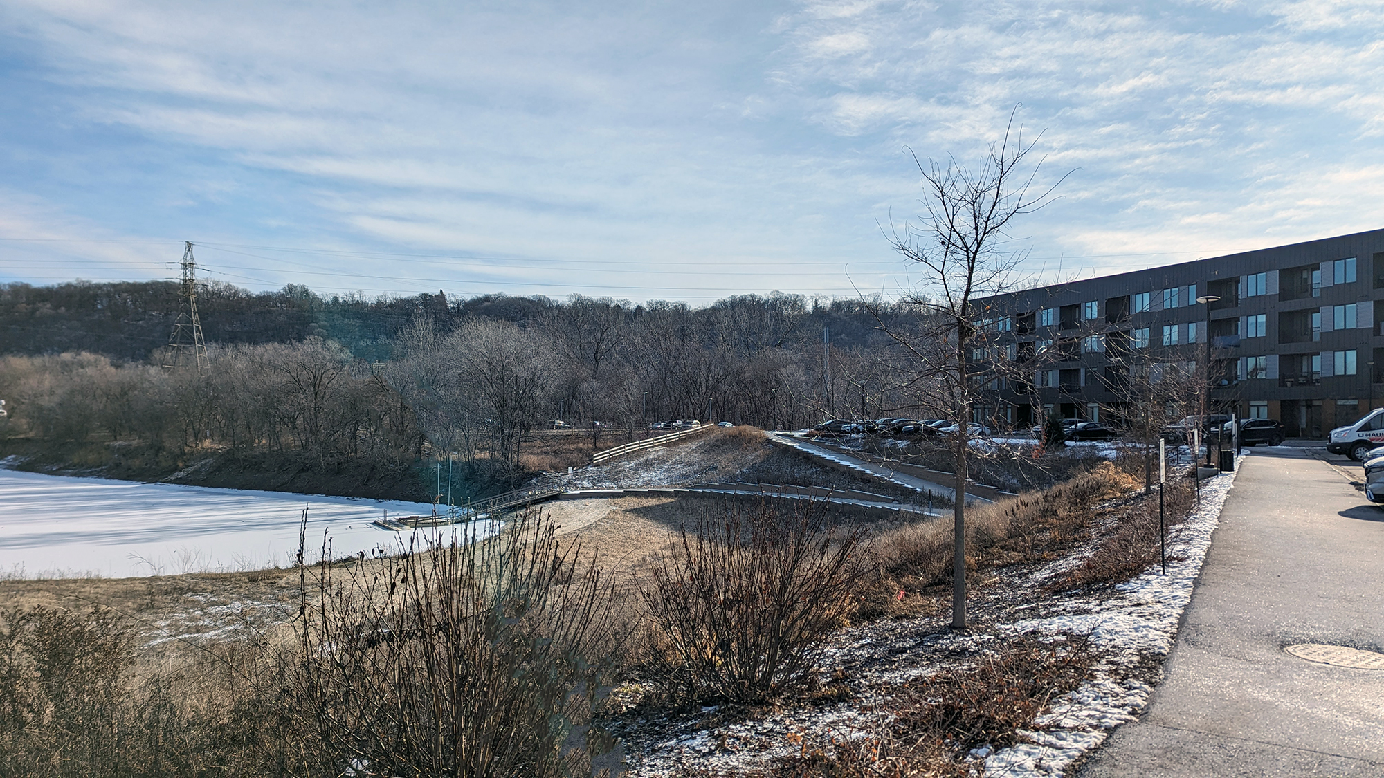
The Waterford Bay development includes a public canoe and kayak launch into a unique backwater bay. Trail connections and free visitor parking help ensure that everyone is welcome to enjoy this area. FMR's advocacy secured more public parkland and access when the development was being planned.
Case study: Parks and trails at St. Paul's Island Station
Island Station is a unique site on a small peninsula near the intersection of Shepard Road and Randolph Avenue in St. Paul. It was once home to a coal-fired power plant.
Island Station is included in St. Paul's Great River Passage Master Plan (which was developed through years of community input and FMR's active support) as a destination for river recreation and community gatherings. The plan calls for trails, a boat launch, recreation and adventure facilities, and public amenities on the site. It emphasizes public ownership and involvement.
Disappointingly, the city chose to allow private housing development on the site instead of preserving it for public use. A 243-unit luxury apartment building, Waterford Bay, opened in 2022.
But we saw opportunities to help ensure that some public access was preserved.
The developer met with FMR and other stakeholders early in the planning process, and we provided feedback about how moderate height, thoughtful building materials, public trails and other design elements could make the development more respectful of its riverfront location.
The developer improved their plan in response to our recommendations. Through FMR's advocacy, the developer agreed to donate more land than the required minimum to the city for public park ownership. The property also includes trails and a carry-in boat launch that are open to the public.
Setting areas aside as public parks ensures permanent access to these amenities for the larger community and strengthens equitable riverfront access for all residents regardless of their income or address.
Respecting the river's scenic beauty

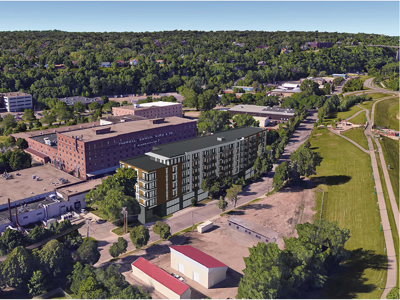
This pre-development rendering shows how the Cordelle building sits between Harriet Island Regional Park and the FOK Warehouse. The new building is shorter than its historic neighbor, meaning that it doesn't block views to or from the river. (Image by DJR Architecture / Reuter Walton Development)
Case study: Scenic views beyond St. Paul's 84 W. Water St. development
A housing project targeted at moderate-income renters, Cordelle, is now open at 84 W. Water St. on St. Paul's West Side, right across the street from Harriet Island. This development required rezoning the site from industrial to residential and granting a variance for height. The existing height limit in the area is four stories, but the developer wanted to build a seven-story building.
Our primary concern with excessive height is its impact on views of and from the river, which in this site includes a scenic view of the bluff rising away from the river behind the site.
However, after we requested and reviewed view analyses from the developer and conducted our own analyses, we found that the proposed height appeared reasonable for this location. The new building would be immediately in front of a historic warehouse that's actually taller and is unlikely to be removed in the future. Any additional impact on views would be minimal given this existing building.
In this urban neighborhood, it's expected that buildings are part of the landscape as long as development is balanced with respecting the river's scenic beauty. This specific site is one place where flexibility on height could support affordable housing and other neighborhood priorities without significantly impacting the community's experience of the river.
When this project was being planned in 2019, we couldn't have known that we would one day become neighbors! But in 2023, FMR moved its offices into the historic warehouse right next door. Our top-floor office still has great views of the Mississippi River.
Learn more
We welcome dialogue with community members, developers, public staff and officials. The earlier we hear about proposed developments, the better. If you have questions about the Land Use & Planning program or would like to discuss specific developments with us, contact Colleen O'Connor Toberman, Land Use & Planning Program Director: ctoberman@fmr.org, 651.477.0923.
Become a River Guardian
Sign up and we'll email you when important river issues arise. We make it quick and easy to contact decision-makers. River Guardians are also invited to special social hours and other events about legislative and metro river corridor issues.